Лаборатория геологии техногенных процессов
Gorbunova K.A., Maximovich N.G., Blinov S.M., Sychkina G.A. Karst water level regime of Kungur cave // Kras i speleologia.-Poland, 1998.-T.9(ХV111).-P.118-124.
KARST WATER LEVEL REGIME OF KUNGUR CAVE
Klara A. Gorbunova Nikolai G. Maximovich,
Sergcj M. Blinov, Galina A. Sychkina
Abstract: Results of karst water level regime research based on hydrometeorological observations performed in Kungur ice cave area (Perm region, Russia) in the period of 1987-1991 are presented in the paper. The relation between level regime of Sylva river and karst water level in the cave is discussed. According to analysis of this relation authors classified karst water fluctuations as nearbank type of regime.
Hydrometeorological observations in Kungur cave are carried out by the Kungur station of the Ural Branch of the Russian Academy of Sciences since 1974. They include hydrodynamic (karst water level), hydrochemical (mineralization and content of main macrocomponents in karst water), geo-thermal (air, rock and groundwater temperatures), periglacial conditions in cave (ice and frozen ground spreading) data. This paper discusses the water level regime of the Sylva river and karst water in the cave over the period 1987-1991. Water level was measured by E.P. Dorofeev on the 14 or 18 day monthly at 17 gauging stations and daily during flood period at 2 or 3 stations. These data were used for chronological diagrams and hydroisohypse maps.
Kungur ice cave is located in the vicinity of Kungur city (Perm region), north-west of Ufimskoye plateau (Gorbunova et al., 1992). The cave entrance is in the lower part of the northern side of Sylva river valley at the level of aggradation terrace (Fig. 1). The terrace width near the cave entrance is 100-150 m, downstream the terrace is pinched out and valley bedside borders the river. The total length of cave passages is 5,6 km.
The cave is developed in gypsum and anhydrite of lower part of the Lower Permian Kungur stage Iren horizon, represented by alternation of gypsum-anhydrite and limestone-dolomite members. In the cave basement, dolomite of the Filippovsky horizon occurs. Eluvial loam and detritic-shaly sediments (their thickness exceeds 10 m) cover Lower Permian rocks. The field over the cave is complicated by numerous sinks, the largest ones are situated over large chamber.
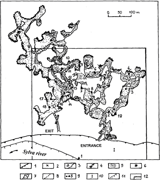 Fig. 1. Kungur ice cave map (by E.P. Dorofeev)
Near-entrance south-eastern part of the cave is cold. Various ice crystals, stalagmites, stalactites, columns and overflow ice occur in that place. Central and north-western part of the cave are notable for more than 60 lakes (Dorofeev, 1975). The cave is horizontal, chambers and passages are stretched mainly north-east and north-west. Karst water in the cave occurs on the Filippovsky dolomite. Rocks forming aquifer are cleaved karstic gypsum, anhydrite and detritic-shaly products of rock disintegration. Aquifer is recharged by atmospheric precipitation absorbed by numerous sinks of over-cave field, condensation water of aeration zone (its thickness is in the range of 70-80 m), river water during flood period. In some areas water inflow from Filippovsky carbonate water-bearing horizon of dome part of Ufimskiy arch takes place. Karst water in the cave is exposed by 3 wells and basins of underground lakes.
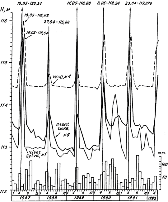 Fig. 2. Diagram of water level fluctuations in the well No. 4, Great lake (No. 6), Sylva river (No. 1) and precipitation over the period of 1987-1991; vertical lines denote flood peaks of Sylva river, figures denote the date and the elevation
The regime of cave massif karst water is formed under the influence of climatic, hydrologic and geologic factors. The climate of the region is temperate continental, average annual precipitation is about 500 mm. Maximum precipitation occurs in summer. Snow cover lasts up to 180 days a year. Climatic factors cause seasonal fluctuations of regime data. They influence the flood height and level of river and karst waters. Spring and autumn floods were registered in 1990 and 1991 (Fig. 2).
The influence of hydrological factors is expressed by close connection of cave karst water level with Sylva river level. During the flood period river water penetrates in cave massif for a short time by infiltration into alluvial deposits of the first terrace or by inflow in karst rocks adjacent to the river. The lowest levels of river water (low-flow) are registered in winter period and before floods (1989-1991). The sharp rise of water level (3-7 m), the flood, falls on the late April and early May (Ejov et al., 1990). Summer low-flow follows spring flood.
The level of lakes in the central part of the cave varies synchronously to Sylva river level but the flood peak delays (from some hours to 7 days) as compared to the river level. In the periods of high floods the water level of underground lakes rises 2,4 m as compared to low-flood level.
In the south-western part, where karstified rocks border the river, during river water penetration into the cave a stream occurs which runs from Tower chamber (No. 18) to Long chamber (No. 12; Dorofeev, 1975) and then to the north (No. 10). Water abates slower as compared to its rise. In rainy 1990 and 1991, lakes level remained high till the next flood. In low-flow period karst water table in this part of the cave becomes almost horizontal (if the gradient is negligible) and there sets up stagnant regime (Fig. 3 A, B).
The regime of the north-eastern part of the cave (Coral chamber, No. 4) differs from that of central part. Here flood peaks occur on the eighth day after the peaks of Sylva river. They are separated by low-flow period of 9-10 months when water level is fairly stable and high (Fig. 2; No. 4).
In low-flow period karst water drainage is directed south-west of Coral chamber to the central part of the cave and then south to Sylva river. Water surface gradient in Coral chamber makes up 0,016, in the rest of the cave it is about 0,0009. In the periods of high spring floods the river water and hydraulically connected with groundwater of alluvial terrace penetrate into the cave massif (Fig. 3 C). The surface gradient of underground stream towards the cave near Sylva river reaches 0,02. Deep into the cave it is gradually reduced up to 0,003. Summer and autumn floods differ from the spring floods by lesser gradients of underground stream (Fig. 3 D). Dynamics of karst water of cave massif in 1987, when high spring occurred, is shown in Fig. 4.
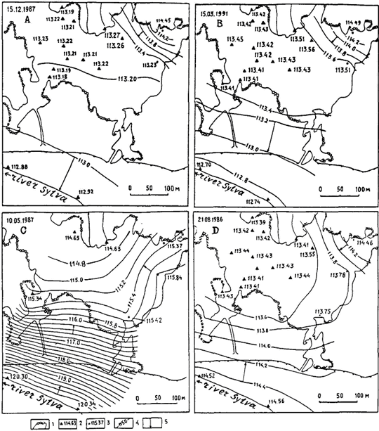 Fig. 3. Hydroisohypse (contour of water table) map of the cave karst water during low-flow period (A, B), the flood peak of Sylva river (C), the summer flood (D)
The following geological factors influence karst water regime: the degree of rocks fissuring and karsting, rock composition and conditions of occurrence. Shaliness, the presence in Coral chamber of weakly karstified pillars (outliers) of poor filtration properties cause considerable gradients of karst water as compared to the rest of the cave.
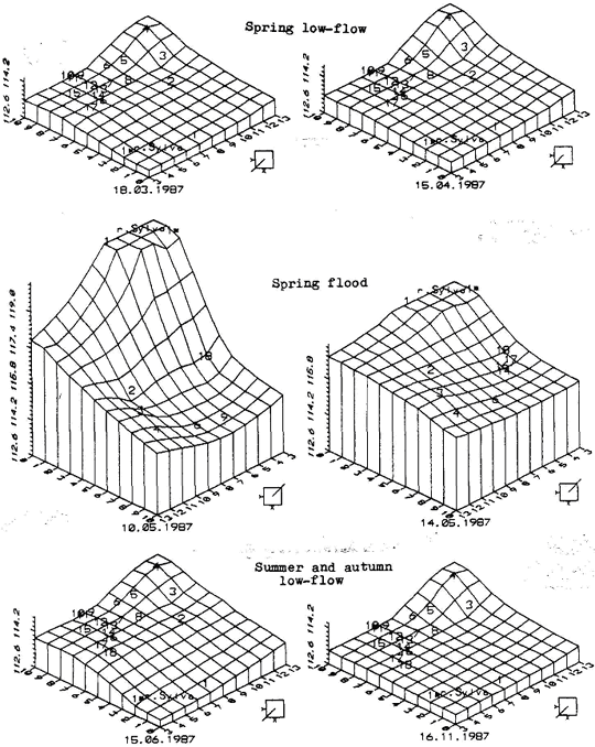 Fig. 4. The models of main hydrological periods of cave massif
According to G.N. Kamensky's classification, the cave massif is attributed to the nearbank type of regime. In heavily karstified areas the nearbank regime is changed by absorption regime and far away from the river it is changed by divide regime.
Regime hydrochemical observations showed that after flood period, mineralization of sulphate-calcium karst water decreases. Water becomes aggressive to gypsum and anhydrite.
Seasonal fluctuations of rock and water temperature, air humidity, air movement, level and mineralization of karst water are the factors that stir karst processes to activity and cause the evolution of a complex cave system.
References
Gorbunova K.A., Andreytchuk V.N., Kostarev V.P., Maximovich N.G., 1992: Karst and caves of Perm region. Perm, 200 p.
Dorofeev E.P., 1975: Connection of the Kungur cave reservoirs with river Sylva. State and problems of karst-speleological investigations. Moscow, pp. 85-87.
Ejov J.A., Dorofeev E.P., Lukin V.S., 1990: Flood in district of city Kungur. Sverdlovsk, 50 p.

|
|
|